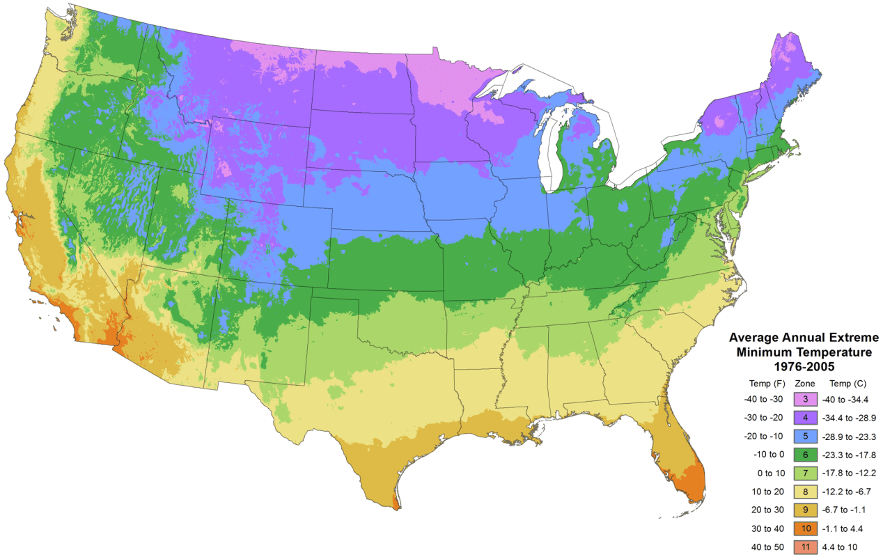
USDA HARDINESS ZONE MAP
A USDA Hardiness Zone Map is a geographical tool used by gardeners and horticulturists to determine which plants are most likely to thrive in a specific region based on its climate conditions. These maps divide regions into zones based on the average minimum winter temperature in that area. Each zone represents a range of temperatures in which certain plants can survive and grow successfully.
The most commonly used Hardiness Zone Map in North America is the United States Department of Agriculture (USDA) Plant Hardiness Zone Map. It divides the United States into numbered zones, ranging from Zone 1 (coldest) to Zone 11 (warmest). For example, Zone 1 includes areas with extremely cold winters, while Zone 11 includes regions with tropical climates where temperatures rarely dip below freezing.
Gardeners and landscapers rely on Hardiness Zone Maps to make informed decisions about which plants are suitable for their area. By choosing plants that are well-suited to the local climate and can withstand the typical winter temperatures, they increase the chances of successful gardening and landscaping projects. This information helps ensure that plants can survive and thrive in a given location, minimizing the risk of frost damage or plant mortality due to extreme cold.
United States Department of Agriculture (USDA) Plant Hardiness Zones by state:
Zone 1:
– States: Alaska (parts of the state, mainly in the northern regions).
Zone 2:
– States: Alaska (parts of the state, including central and southern regions).
Zone 3:
– States: Alaska (parts of the state, primarily in the southern regions).
– Additional State: Northern parts of Minnesota and North Dakota.
Zone 4:
– States: Montana, Wyoming, South Dakota, North Dakota (most of the state), Minnesota (northern regions), Wisconsin, Michigan (Upper Peninsula), Maine, New Hampshire, Vermont, upstate New York, and northern Idaho.
Zone 5:
– States: Washington (eastern parts), Oregon (eastern parts), Idaho (southern parts), Nevada (parts), Utah (parts), Colorado, Nebraska, Iowa, Wisconsin (southern regions), Illinois, Indiana, Ohio, Pennsylvania, New York (most of the state), Vermont (southern regions), New Hampshire (southern regions), and Massachusetts.
Zone 6:
– States: Washington (western parts), Oregon (western parts), Idaho (northern parts), Montana (western parts), Wyoming (northern parts), Nevada (parts), Utah (northern parts), Colorado (southern regions), Kansas, Missouri, Illinois (southern regions), Kentucky, Tennessee, North Carolina, Virginia, West Virginia, Maryland, Delaware, New Jersey, and parts of Arkansas, Oklahoma, and Texas.
Zone 7:
– States: California (parts), Arizona, New Mexico, Texas (parts), Oklahoma (parts), Arkansas (parts), and Mississippi.
Zone 8:
– States: California (most of the state), Arizona (southern regions), New Mexico (southern regions), Texas (most of the state), Louisiana, and parts of Florida and Alabama.
Zone 9:
– States: Southern Florida and the southernmost parts of Texas and Arizona.
Zone 10:
– States: Southern Florida and the southern tip of Texas.
Zone 11:
– States: Hawaii, Puerto Rico, Guam, and the U.S. Virgin Islands.
Please note that within each state, there can be local variations in climate and temperature, so it’s essential to consider microclimates when selecting plants for specific locations. The USDA Plant Hardiness Zone Map provides a helpful starting point for plant selection and landscaping planning.